Phoenix77
Premium
It particularly does when viewing from a higher view point.Needs foilage and rock/hills textures soon!
Unless you're offering to help Ben out mate... that's kind of just stating the obvious, that's already been stated more than a few times
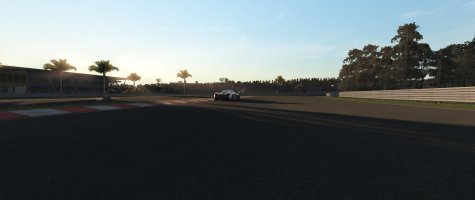
That's not really relevant to the canyons though... look at all that flat space you have round Nords to have space to do the tree walls... The tree wall textures would get skewed... as you don't really have any flat areas, around the canyons... parallel to the track.You can use treewalls relatively close to the track on a lot of the hills, just stack em in rows. Have a look at nordslejfe, the hill at Ex-Mühle for example (at 2:46 here).
That is about the best way to do the hills at distance:
View attachment 260747
Even when they're parallel for a short distance... they have their own elevation changes along the X!
The only place tree walls may be ok to uses is along some of the tops of the ridges.
The Nordschleife is as flat as a pancake compared the canyons... the elevation change (over distance) is around 4,400 ft... 1,800ft in La Canada... around 6,200ft at Strawberry Peak.