Hi guys! My name is Luca and I'm writing from Italy.
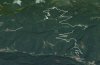
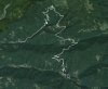
I'm in trouble to realize the ground mesh and the terrain for a special track of the Italian Rally 2014. I traced the path with a gps about every 5-10 meters with attached more than 6 satellites. I think it's a good elevation data to start. Maybe I can try to smooth the track with 3D Route Builder if it's necessary.
So ... now I want to know if there is a short way to conform the real terrain and the far scenery of the location around the track. Until now I only imported the .kml in BTB. I'm also new user in 3DSmax and blender ... so if it's needed to make a good and quick job PLEASE let me know how ... step by step if it's possible or in alternative ... where I can find a guide for dummies? Thank you in advance.
Luca
PS: sorry for my bad english