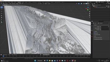
Tracks Lidar Track Building Strategies - Discussion - Info Pool - Progression

Si

Could i merge the road that i had from LiDAR data with a DTM heightmap? Thanks for the help btw!

Yeah that's what I do. Basically use a hillshade heightmap for the general terrain distant mountains etc, then use the LIDAR just as a guide for the road + location of walls/cliffs/buildings. Then once the terrain is all modeled and linked to the road mesh, I paint the terrain texture mask.
 
Yeah that's what I do. Basically use a hillshade heightmap for the general terrain distant mountains etc, then use the LIDAR just as a guide for the road + location of walls/cliffs/buildings. Then once the terrain is all modeled and linked to the road mesh, I paint the terrain texture mask.
That's awesome, thanks a lot! i'm learning a bit slowly, sorry for all the questions, but i'm new to all this, i'm enjoying it a lot anyway.
 
I have the mesh from LiDAR and it works fine and fluidly ^^, now i have to do/import the road
 

Attachments

  • zx.jpg
    zx.jpg
    535.8 KB · Views: 50
@wimdes
Here you go, thank you so much! (i changed the stage btw, the las files from the other ones were way harder to load for my pc, almost impossible, these work incredibly fine!)
What kind of editing did you do on the .las files - did you reproject into ETRS89 / EPSG 4258?
Best keep the original CRS

If you have those other las/laz files I can have a look as well (they'll become much lighter)
 
They should be edited by the own source, as these are the original files and they already had edited in the name. I'll upload the other las/laz files too then, i can't thank you enough, really
 
They should be edited by the own source, as these are the original files and they already had edited in the name. I'll upload the other las/laz files too then, i can't thank you enough, really

The reason I thought it was edited is because it's in a spherical coordinate system, for my flow I'd first have to translate it into an XYZ system but I think/hope that shouldn't be a problem. Starting from a ground-classified lidar file + a gpx I can now automatically process it into a much lighter file, keeping max detail on/around the road, then decrease in a number of zones by distance. The original laz file (= compressed las) of our Ypres stage is 8GB to start with, it took my computer a bit over 1 hour to reduce it to 50MB, looking like this:

lidar-thin.png


In any case, if you have no previous experience with Blender, be prepared... it won't be easy. Start by working through a lot of tutorials to learn the basics, and it will help in understanding why stuff never works as expected ;)
 
They should be edited by the own source, as these are the original files and they already had edited in the name. I'll upload the other las/laz files too then, i can't thank you enough, really

The reason I thought it was edited is because it's in a spherical coordinate system, for my flow I'd first have to translate it into an XYZ system but I think/hope that shouldn't be a problem. Starting from a ground-classified lidar file + a gpx I can now automatically process it into a much lighter file, keeping max detail on/around the road, then decrease in a number of zones by distance. The original laz file (= compressed las) of our Ypres stage is 8GB to start with, it took my computer a bit over 1 hour to reduce it to 50MB, looking like this:

View attachment 656702

In any case, if you have no previous experience with Blender, be prepared... it won't be easy. Start by working through a lot of tutorials to learn the basics, and it will help in understanding why stuff never works as expected ;)
Wow man, this is awesome! Thank you so much for your help, i have to learn to do that (i'm also watching a loooooot of blender tutorials haha)
 
How did you merge the gpx with the LiDAR? So next time i can do it myself, I couldn't find a way in CloudCompare

You can't merge GPX with the lidar/point clouds. It first has to be converted to a vector format, from where contours are generated at set distances into shapefiles. Then these are used to cut the lidar data in zones, apply thinning to each zone, then merge again. Steps are now automated but I'm not ready to share the script yet - but I'm willing to run it on provided data, on condition it's for public AC rally tracks ;)
 
You can't merge GPX with the lidar/point clouds. It first has to be converted to a vector format, from where contours are generated at set distances into shapefiles. Then these are used to cut the lidar data in zones, apply thinning to each zone, then merge again. Steps are now automated but I'm not ready to share the script yet - but I'm willing to run it on provided data, on condition it's for public AC rally tracks ;)
Wow i didn't know you already managed to automatize it, that's incredible news
 
Last edited:
No, the DTM is like a lower resolution terrain model, here you automatically get the lower res for the more remote terrain. The lidar data is quite manageable now but then the hard part begins :geek:
I had a look at the original file, there were some trees above the road indeed
 
No, the DTM is like a lower resolution terrain model, here you automatically get the lower res for the more remote terrain. The lidar data is quite manageable now but then the hard part begins :geek:
I had a look at the original file, there were some trees above the road indeed
Perfect, i'll try getting more blender knowledge first, and can i drap ortophoto onto it later in blender?
 

Latest News

Are you buying car setups?

  • Yes

  • No


Results are only viewable after voting.
Back
Top