Tracks Lidar Track Building Strategies - Discussion - Info Pool - Progression

Hey, open discussion and resource for track builders to share workflows, strategies and your process of building tracks.

- currently im building a fictional rally stage based in the UK on the border of england and wales. My experience with Assetto Corsa (just bought it last week :D ) and track building is limited but have some prior knowledge of blender.

My thoughts so far as to how to get started -

- Mapping - google , bing , sasplanet for searching your desired location
- Finding if that area is covered with LIDAR data for example in the UK
- .laz files is what im using at the moment but that may change if a better alternative arises.


The coverage will vary depending on location, be aware of this before fully deciding on your location.
i will be looking into all countries to find the data as a resource.

once you've found your location and got the data, you'll need software to read it.

Cloud Compare - view, edit and optimise 3D point cloud > export mesh
QGIS - orient your position when viewing lidar if you cant understand where the LIDAR capture has been taken. Use HCMGIS and change opacity in the layer properties, double click layer, look for transparency > opacity or go to symbology > opacity. can use this a an overlay to your .laz file
-side note - - i was looking for this area for ages trying to find reference point to where i was on the LIDAR map in Cloud Compare and had no idea .... turns out it was a capture of another area north of where i had taken the data from.

Meshlab - to optimise mesh, reduce poly count where needed. LIDAR Meshes are DENSE AF.

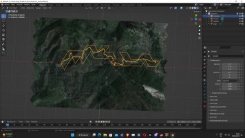
This is where i'm up to at the moment, trying to optimise where i can to load it into Blender for adding the next pieces. Its a slow process at the moment but rewarding.

Looking forward to chatting with you about your progressions, workflows, ideas and together we can make this process streamlined and build awesome tracks.
 
If you know how to optimize the laz file on cloud compare before exporting to mesh i would be glad to know, i'm a little bit lost
would suggest, looking at linski's video, but the general idea is to cut away what you dont need.
Screenshot 2023-04-12 220507.jpg

1 .top left is scissors - make sure your layer is selected or its greyed out
2. selection type blue square with dropdown arrow, rectangle for big chunks, then polygonal for finer cuts
3. when you made your selection, choose red circle or red box to make the cut
4.click green tick top right.
5. delete layer
- repeat till your left with the area you need.
 
would suggest, looking at linski's video, but the general idea is to cut away what you dont need.
View attachment 655042
1 .top left is scissors - make sure your layer is selected or its greyed out
2. selection type blue square with dropdown arrow, rectangle for big chunks, then polygonal for finer cuts
3. when you made your selection, choose red circle or red box to make the cut
4.click green tick top right.
5. delete layer
- repeat till your left with the area you need.
I've done it already haha, maybe i'll have to cut more terrain, it's a 10km approx stage
 
Awesome sounds great, glad you sorted it ! drop a screen cap would like see ^^
i'll send you a picture of the point clouds tomorrow, but the track is this one, i'm doing it from the beggining till the part that is more or less near "Melezna"

Here is also an on board:
 

Attachments

  • mapaCorullon22 (1).jpg
    mapaCorullon22 (1).jpg
    451.9 KB · Views: 46
(learning) idea on how to visualise optimisation

in cloud compare segment main area then into
-road
-buildings
-fields / scrubland / hedges
-delete trees

then use google street view to drive along road (even better drive on road with 360 cam on roof ^^)
looking at the areas visible forwards and backwards and cut away what's not visible.

then for exporting separate files into
-road
-buildings
-landscape
-deleted trees

import into mesh lab for optimisation :)
 
i'll send you a picture of the point clouds tomorrow, but the track is this one, i'm doing it from the beggining till the part that is more or less near "Melezna"

Here is also an on board:
cool, sounds good! you and me both, never done a project like this either ;)
will have a watch, from the map it looks great very twisty!
 
(learning) idea on how to visualise optimisation

in cloud compare segment main area then into
-road
-buildings
-fields / scrubland / hedges
-delete trees

then use google street view to drive along road (even better drive on road with 360 cam on roof ^^)
looking at the areas visible forwards and backwards and cut away what's not visible.

then for exporting separate files into
-road
-buildings
-landscape
-deleted trees

import into mesh lab for optimisation :)
That's pretty helpful, i'll do it like that, thanks a lot! How is segmentation in CC?
And yeah i'm stoked to do that and see there are more people than want to start doing that, we have a lot of very cool cars but few tracks.
Btw, the guy from Kronos is realasing a new track too in the next days, and it looks awesome. He'll be opening a patreon to also acquire older tracks from him
welcome !
its fair, but the tools i still need to get to grips with (only day 2) , there are surely better ways to sort the data, but thats part of the process making the mistakes to create.
yeah for sure, many cars fair few tracks, but not enough really good ones, see this as the next RBR.
Ohh! ok sounds good will look forward to seeing that, link it here when you do please, be really nice to see how the pros do it.
 
I just thought something, would be editing and converting to mesh each laz file separately possible, and then putting them together in blender? That would help me with the limited ram issue.
 
I just thought something, would be editing and converting to mesh each laz file separately possible, and then putting them together in blender? That would help me with the limited ram issue.
yes pretty sure, meshlab or z-brush if you have it, would be before blender though. you can reduce poly count there majorly and still keep good shape definition. ;)
 
In my case the LiDAR data comes in like 5 different laz files, if i can work on each one of them individually that would be much better
right, yes i agree, i haven't had to do this yet, sure there are tutorials for stitching or combining , at this point in time and knowledge i would suggest qgis but i'm not sure if that's the best for the job, have a look about for best for point cloud stitching, there will be an a solution.
some tiles some are in single files. look forward to see what you find ;)
 
So for now i find dealing with LiDAR data too hard for me, i find little information on how to do it properly, and my PC is nice but not good enough, if you guys can in the end make some kind of guide i'll switch :). For now, there's my track made from google data:
 

Attachments

  • Sin título.jpg
    Sin título.jpg
    502.5 KB · Views: 60
So for now i find dealing with LiDAR data too hard for me, i find little information on how to do it properly, and my PC is nice but not good enough, if you guys can in the end make some kind of guide i'll switch :). For now, there's my track made from google data:
understandable, its hard for sure, my brain ache is strong, but when you try again it does get easier. yeah, if you can do it that way, go for it! making it that way will teach you loads that you have to know either way. there will be a guide at some point 100% just need to iron out the creases in terms of best practices, which at the moment i still dont know, learning as i go. this is what this thread is about, progression in any way possible we learn together!

that looks really good area for a track !! looking forward to the next steps you take :)
 

Latest News

Are you buying car setups?

  • Yes

  • No


Results are only viewable after voting.
Back
Top