Hi,
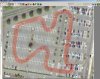
New to BTB and am attempting to create a track for rFactor. My son races go karts at a temporary circuit every Saturday (during the warmer months) in Norwalk, CT USA. Being the off season now, I thought it would be really nice to use BTB to allow him to practice his lines, and get prepared for the upcoming season. I've created a path in Google Earth and imported it into BTB.
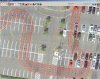
Here's where the problem begins, the track surface is imported, but it brings alot of data surrounding the paths I've created, which it considers to be part of the track surface. All of my original control points from Google Earth are there as well, but the edges of the racing surface are unclear in any view.
How can I use the existing control points to either "paint" a line to represent the edges of the track surface, or to limit the track surface area.
Thanks,
James
New to BTB and am attempting to create a track for rFactor. My son races go karts at a temporary circuit every Saturday (during the warmer months) in Norwalk, CT USA. Being the off season now, I thought it would be really nice to use BTB to allow him to practice his lines, and get prepared for the upcoming season. I've created a path in Google Earth and imported it into BTB.
Here's where the problem begins, the track surface is imported, but it brings alot of data surrounding the paths I've created, which it considers to be part of the track surface. All of my original control points from Google Earth are there as well, but the edges of the racing surface are unclear in any view.
How can I use the existing control points to either "paint" a line to represent the edges of the track surface, or to limit the track surface area.
Thanks,
James
") ). So work hard at getting it as close as you can. It is possible, but it takes a lot of hard work and focus.
). So work hard at getting it as close as you can. It is possible, but it takes a lot of hard work and focus.