Support for higher resolution background images?

Hi,

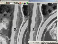
My problem is that I have a very accurate aerial image of my track and the image size is 12288 x 12288 (17,32 Mb JPEG). BTB does load it, but the resolution of it is downsized to something much smaller.

I attached an image of the problem. The left side is BTB and the right side is the aerial image (100% zoom).

Is there any way to go around this or can BTB be programmed to support higher resolution images?

Thanks!
 

Attachments

  • bg_image_resolution.jpg
    bg_image_resolution.jpg
    132.9 KB · Views: 353
Jesse -

I knew you had bought the hi-res aerial photo from USGS, but I didn't realize you're working on Meadowdale! Yippee!

Okay, got that out of my system. Short answer is that 4096x4096 for a background image is the max as far as I know.

Honestly, I can't see enough difference in those screenshots to matter for the purposes of making a track, especially since you won't be using the B&W image for a blending texture. Major reason is that your accuracy will not take into account the curvature of the earth and the field of view for the camera. Second reason is that the resolution of altitudes from online sources is not as good as the image you have, even without curvature corrections (unless you have heavily surveyed those altitudes).

Emery,

My MIR project is introduced at the WIP Tracks-forum (not much there) and at Autosport.com Nostalgia Forum. I'm really glad that I picked this track since it's such a blast to drive!

My main usage for the background image is placing objects, walls, etc. very accurately. There really is a difference and it is emphasized when zooming in. If you look at the aerial image and inside the curve you can even see the tires that are sunk to the ground (those evenly spaced bright spots very close to the track), but they're not visible in BTB. With the same resolution as the aerial image, I could place those tires very accurately in BTB! There's also lots of other small details that are "lost" with the lower resolution image in BTB.

About the general accuracy you mentioned. As this is a track that no longer exists, the aerial image is the most accurate thing I can use. I created the track using Google Earth and after that I added the image as background. After resizing it to match the track, it was almost a perfect fit! The track widths were measured at the real track and those measurements fit almost perfectly with the image too!! The altitudes are a problem, but I'm using two different techniques to get them as accurate as possible.

lordpantsington, good idea, thanks! I'll try that, but I still wish BTB would someday support larger images directly.
 

Latest News

Are you buying car setups?

  • Yes

  • No


Results are only viewable after voting.
Back
Top