How do you create smooth altitude changes?

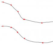
What are the basic steps to take that the altitude changes (altitude profile curve) are smooth? I've tried all the smooth options, everything possible with the nodes and the node control points with no luck. It looks pretty ok in BTB, but in rFactor the track is like the upper part in my highly detailed image :wink2: What I would want is the lower picture. (red dots are the nodes)

Thanks!
 

Attachments

  • altitudes.jpg
    altitudes.jpg
    55.1 KB · Views: 280
Yes I have doen that to the whole track, parts of the track and to single nodes, but with no luck.

Because the picture I made might not be the best possible :rotfl: the thing is that the section BTB makes are kind of straight (altitudewise) and kind of only short curves between those section. What I'd want is that the whole section is curved.
 
I found a free soft... 3D route builder, it have an add altitude tool and smoth tool which interpolate the nodes of the track and work fine with KML archives from google earth.

i can`t find a solution inside BTB for altitude smoth so i do it before work on BTB.

that method isn´t good for real value, but nice becouse is free data, and if you play with it, you will smoth all your track very quick.

you cant load BTB files on 3D route builder, and you need to change some things inside KML file to load it from google earth, but it works.

create your track on google earth, give altitude and smoth it in 3D route builder and finally import it to BTB and strat to work in a smoth track.
 
Thank you liquido!

My problem is that the track doesn't exist anymore. Well it does kind of, but the altitudes from Google Earth are quite unaccurate and mother earth has destroyed the track from few parts. I have very accurate aerial image and altitude data from 1960's which I'm using and I hope I can continue working with them.

BTW, did you know there's a program called BTBLofty which should also smooth out your tracks. It uses BTB track data and KML data and you don't have to edit the KML data before using it in the program. I can't use it myself as I don't have (or can't create) the KML data. I haven't tested it either so I don't know how well it does the job.
 
think you need to play with the handles attached to each node. If they're too close to the node, and the nodes are too close together at different angles, you'll get abrupt transtions on the road surface. Moving the handles away from the nodes smooths out the transition of the surface over the node. Hope this helps!
 

Latest News

Are you buying car setups?

  • Yes

  • No


Results are only viewable after voting.
Back
Top