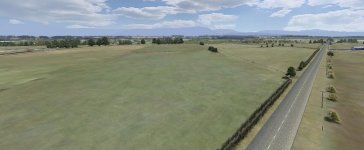
for Longford i took around 80 close up (best resolution available from GE) printscreens and 'stitched' them together in photoshop, which made for quite a large image. I then cropped and resized it down to 4096x4096 and removed the modern highway (the track is based in 1967) and removed some trees and put others in to be accurate for the period, painted some shadows and gravel etc (a great way to fake shadows further from the track).
I down-sample to 1024x1024 for the 7km track for use ingame/btb (4096x4096 was having a big impact on load times). Because there are big flat paddocks around the track i made another image at 512x512 to cover the distant hills and paddocks up to 2km away from the track, so yes, i have long clip-planes.
very usefull for road shapes, radius etc. great for placing trees, bushes, houses, fences. Also, you can judge terrain height changes by different tones in the grass. For Longford i also pulled out a bit of green channel in the image which i felt was a bit rich. It looks a lot more natural now, but that will depend on your GE source images and the weather conditions.
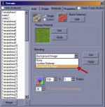
But you really should map it to the terrain as well with the background image blend option in the terrain materials panel, then you get it in wonderful 3D as well, with the regular texture's 'add' (and maybe 'multi'?) textures too, just for some extra detail. It would be a shame if any racing game from now on doesn't support such a feature. It looks incredible when compared to the same texture repeated around the track. I can't really imagine a more accurate and appropriate way to texture the ground. Made even better because we can blend it with the magnificent PiddyProg (aka BTB) for areas close to the road where resolution can be an issue. One of the best things you can do for a track.:good:
edit: added pic. in this instance the distant hills are on the skybox, but you can see the GE image in the paddocks